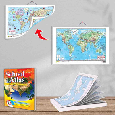
SMALL - 100 WORLD POLITICAL OUTLINE MAP FOR SCHOOL, 2 IN 1 WORLD POLITICAL AND PHYSICAL MAP IN ENGLISH and SCHOOL ATLAS LATEST EDITION (ENGLISH) - ART PAPER | Pack of 1 Map Pad + 1 Map Chart + 1 Atlas Book | Geography Made Simple: All-in-One Maps and Atlas for School Education Paper Print(30 inch X
Quick Overview
Product Price Comparison
"Gowoo's latest educational offerings are designed to enhance students' knowledge and understanding of world geography. Gowoo presents SMALL - 100 WORLD POLITICAL OUTLINE MAP pad, a versatile 7 by 8 inch tool, perfect for school use.The SMALL - 100 WORLD POLITICAL OUTLINE MAP pad is essential for geography classes and educational activities. Each sheet features a clear outline map of the world, allowing students to practice labelling countries, continents, and major geographical features. The compact size of the pad makes it convenient to carry and store, ensuring easy access for both teachers and students.For a more comprehensive learning experience, Gowoo offers the 2 IN 1 WORLD POLITICAL AND PHYSICAL MAP chart. This large-format chart measures 20 by 30 inch, clearly representing the world's political boundaries and physical features. Students can explore the interplay between natural landscapes with this chart, fostering a deeper understanding of global dynamics. Including political and physical elements on a single chart enables students to grasp the relationship between geography.Both the SMALL - 100 WORLD POLITICAL OUTLINE MAP pad and the 2 IN 1 WORLD POLITICAL AND PHYSICAL MAP chart are available in English, ensuring accessibility for students worldwide. The English version allows students to familiarize themselves with internationally recognized place names, facilitating communication and understanding across borders.Gowoo offers the SCHOOL ATLAS LATEST EDITION (ENGLISH) - ART PAPER to further enrich students' geographical knowledge. This comprehensive atlas measures 8.5 by 11 inch and features a glossy cover with perfect binding, making it durable and visually appealing. The atlas contains a wealth of up-to-date information, including detailed maps, thematic sections, and statistical data on various countries and regions. Including art paper ensures that the maps are of high quality, enhancing readability and visual clarity.The SCHOOL ATLAS LATEST EDITION (ENGLISH) - ART PAPER covers various topics, such as political geography, climate, population, and economic indicators. It is an invaluable resource for educators, enabling them to design engaging lesson plans and activities. Students can explore the world's continents, countries, and cities, comprehensively understanding global geography and political systems.In conclusion, Gowoo's educational products, including the SMALL - 100 WORLD POLITICAL OUTLINE MAP pad, 2 IN 1 WORLD POLITICAL AND PHYSICAL MAP chart, and SCHOOL ATLAS LATEST EDITION (ENGLISH) - ART PAPER, offer students and educators valuable tools to enhance their knowledge of world geography and politics. These resources are thoughtfully designed, visually appealing, and up-to-date, making them indispensable for classroom use. Whether practising labelling on a compact map pad, analyzing the interplay of politics and geography on a large-format chart, or delving into comprehensive information in an art paper atlas, Gowoo provides the tools for a rich educational experience."

